big sur
Where the Mountains Fall Into the Sea
Where the Mountains Fall Into the Sea ? Driving Big Sur's Wild Coast ? Highway 1
Where the Mountains Fall Into the Sea
For roughly ninety miles, the Santa Lucia Mountains don't merely meet the Pacific — they collide with it.
Highway 1 · Carmel to San Simeon · 90 Miles of Coast
2I have tried, more than once, to describe Big Sur to someone who hasn't been. I always fall short. For roughly ninety miles between Carmel and San Simeon, the Santa Lucia Mountains don't merely meet the Pacific Ocean — they collide with it, hurling granite cliffs into churning surf, threading a two-lane ribbon of asphalt along edges that made me grip the steering wheel tighter than I care to admit. The phrase "breathtaking drive" gets thrown around too easily in travel writing. On Highway 1 through Big Sur, it is simply accurate.
I've driven this coast more than once now, and what I've learned is that it rewards the people who slow down. The famous landmarks are worth every photograph. But the quieter discoveries — an unmarked gate number beside the highway, a staircase descending into flowers — are what I find myself describing to people years later. These four stops tell the full story of the coast for me, from its hidden wildflower valleys to its world-famous waterfalls and the dramatic southern gateway where the mountains make their final, breathtaking plunge.
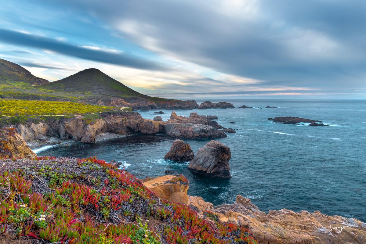
The bluffs of Garrapata State Park — nineteen unmarked pullouts hiding one of the coast's most unspoiled shores.
Garrapata State Park: The Hidden Gem I Almost Drove Past
I'll be honest: I drove past Garrapata State Park the first time I visited Big Sur. There are no grand entrance signs, no visitor booths — just nineteen discreetly numbered turnout markers on the oceanside of the highway, easy to miss at highway speed if you don't know to look for them. That obscurity, I've come to think, is part of the charm, and part of why the park feels so remarkably unspoiled.
Set at the base of the Santa Lucia Mountain range and covering nearly 3,000 acres, Garrapata reaches from rugged sea caves and rocky shoreline to deep inland canyons and steep mountainous terrain — a range of landscapes I genuinely didn't expect from what looks, from the car window, like a simple coastal pullout. I spent a morning on the Garrapata Bluff Trail, a roughly mile-long walk of flat, wind-scoured coastline, and found myself stopping every hundred yards to stare at the ocean below. Gray whales pass these waters during migration. Sea otters bob in the kelp. It is the kind of place that quietly rearranges your priorities.
Calla Lily Valley: The Secret That Stopped Me Cold
A short drive south within Garrapata's boundaries, I found the thing I now consider the single most surprising discovery on the entire Big Sur coast. Calla Lily Valley is a small canyon along Garrapata State Beach where calla lilies bloom in late winter and spring, reachable via a 0.4-mile out-and-back hike from Gate 18.
The approach gave nothing away. I walked a dusty trail toward the ocean, saw no flowers, wondered briefly if I'd found the wrong gate. Then the trail hit a set of wooden stairs, and I descended into a narrow canyon that was, without exaggeration, carpeted in white blooms. Bunches of calla lilies surrounded a creek running down to the ocean, with the Santa Lucia Mountains rising above the valley behind. I stood there for a while without taking a single photo, which is rare for me.
Planning Your Visit to Calla Lily Valley
- Peak bloom: Mid-February to mid-April
- Trailhead: Gate 18 along Highway 1 within Garrapata State Park
- Hike length: 0.4 miles out-and-back
- Arrive early: Parking fills by mid-morning on weekends
- What to wear: Long pants (poison oak present), waterproof boots after rain
- Don't miss: The view back into the valley from the bluffs above — arguably better than the canyon floor itself
Peak season for the bloom runs roughly mid-February to mid-April, so time your visit accordingly. I'd also strongly recommend arriving early on weekends — this spot has become well-known enough that parking fills by mid-morning. Wear long pants for the poison oak, bring waterproof boots if there's been rain, and after you've had your fill of the canyon, climb back up to the bluffs and look down into the valley from above. That view, with the Pacific glittering in the background, might be even better than the one from inside it.
"I descended into a narrow canyon that was, without exaggeration, carpeted in white blooms — and I stood there for a while without taking a single photo, which is rare for me."
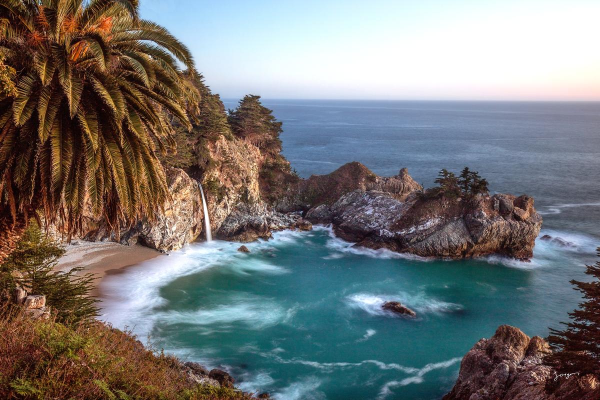
The tidefalls cove at McWay — turquoise water against pale sand against black cliff, a visual that no frame fully captures.
McWay Falls: Nothing Quite Prepares You
I thought I knew what McWay Falls would look like. I had seen the photographs. I was wrong about how it would feel to actually stand there.
McWay Falls is an 80-foot waterfall that flows year-round from McWay Creek into a Pacific Ocean cove inside Julia Pfeiffer Burns State Park, about 37 miles south of Carmel. The contrast — white water against turquoise surf against pale sand against black cliff — is the kind of visual that makes you reach for your camera and then put it down again because no frame does it justice. I did both, several times.
What I hadn't known before visiting was the geology behind that perfect sandy cove. A massive 1983 landslide deposited material at the base of the slope, and wave action gradually transported it south, forming the beach where none had previously existed. Before that landslide, the falls dropped directly into open ocean. Now they meet the sea only at high tide, making McWay one of the rare "tidefalls" in the world — a technical designation that doesn't quite capture how otherworldly the whole scene looks at high water.
The Waterfall Overlook Trail might be the biggest-bang-for-not-much-work hike on the planet — a half-mile round trip through a short tunnel beneath Highway 1 to a viewing deck perched above the cove. One important note: as of 2025, the overlook trail has been closed for a retaining wall repair project, and the falls are viewable from a roadside pullout on Highway 1. Check the California State Parks website before you go. Either way, I'd say it's worth planning your entire day around.
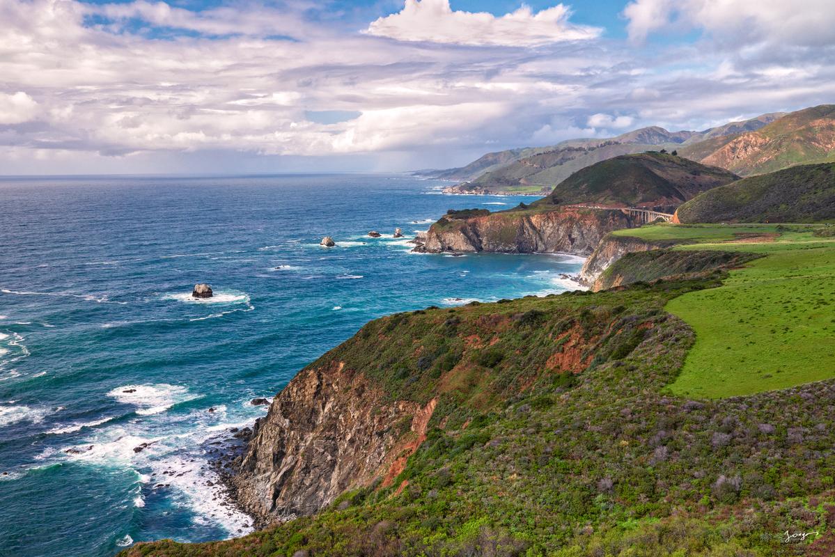
Ragged Point: Where the Mountains Finally Let Go
After hours on the road through Big Sur's wild interior, arriving at Ragged Point felt like reaching a punctuation mark — the coast's grand, definitive period. The point sits 400 feet above the Pacific, with views stretching for miles across deep blue ocean, waves crashing on remote beaches below. Locals have always called it the "Million Dollar View," and standing at the cliff edge watching the afternoon light flatten out across the water, I couldn't argue with the valuation.
Few places I've been can match Ragged Point's combination of endless blue horizon, wildflower-dotted mountains, and majestic cliffside vantage points. I took the Cliffside Trail down to the black-sand beach — a steep, demanding half-mile descent of roughly 400 feet that I would not recommend in wet conditions or unsupportive shoes. At the bottom, Black Swift Falls spills from the bluffs above, and the view looking back up at the cliff face you just descended is one of those perspective-shifting moments that Big Sur specializes in. My legs complained on the way back up. I didn't care.
For those who'd rather keep their feet on the clifftop, there are benches positioned right at the edge with long views both north toward Big Sur and south toward San Simeon. I sat at one for longer than I'd planned, watching a cargo ship move slowly across the horizon, and felt the specific, rare contentment of having nowhere else to be.
One practical note: the Ragged Point Inn has one of the very few gas stations on this stretch of coast. I filled up there even though I didn't need to, because running low on gas on a switchback a few hundred feet above the Pacific seemed like an outcome worth avoiding.
Ragged Point at the southern end of the drive — the coast's grand punctuation mark, 400 feet above the Pacific.
What I'd Tell Someone Planning This Drive
Go in spring if you can — the wildflowers are at their peak, the calla lilies are blooming, and the whale-watching from coastal overlooks is exceptional. Summer brings the marine fog layer that rolls in each morning and burns off by early afternoon; I've driven the coast in thick fog and found it eerie and beautiful in a completely different way. Fall is warm and golden but brings wildfire risk, so check conditions before heading out.
Leave your phone's navigation running but don't expect it to save you — cell service disappears for long stretches through Big Sur. Download offline maps, carry extra water, and give yourself more time than you think you need. Every time I've driven this coast with a firm schedule, I've broken it. Every time I've driven it without one, I've come home wondering how I'm supposed to go back to ordinary roads again.
Where the Mountains Fall Into the Sea · Driving Big Sur's Wild Coast · Highway 1
