I have been chasing waterfalls up and down the West Coast for years now, and every one on this list I have returned to more than once. That repetition matters, because a waterfall is never the same place twice. The same falls in April, fed by snowmelt pouring down from the mountains above, will be a completely different animal than the same falls in October, when the flow has thinned to a fraction of itself and the surrounding forest has gone gold and rust instead of green. I have stood in the same spot at the same waterfall in spring and fall and come away with photographs that look like they were shot at two entirely different locations on two entirely different continents. That is part of what keeps me coming back.
There is something else I want to say before getting into the list itself, because it is the thing I actually think about most while standing at the base of these falls with my camera. Water is the oldest thing on this planet. It was here before sunlight ever touched the surface of the Earth in the way it does now — the primordial waters predate the energy and awareness that came with the sun. If sunlight is associated with consciousness and awareness, water is associated with something even older: truth itself, the foundation everything else moves through. A river or a waterfall is that ancient truth in constant motion, and I think that is exactly why standing in front of one does something to people that standing in front of almost nothing else does. Water is the actual source of life on this planet. Being near a large moving body of it puts you in direct contact with the same force that makes everything else possible. It teaches you things. It has taught me things, repeatedly, over the years, usually without a single word being involved.
This is not just my own private theory, either. Indigenous communities up and down this coast have used waterfalls as sites of ritual and rite of passage for as long as anyone has kept records, and as you will see throughout this list, nearly every waterfall here carries its own sacred history with the people who lived alongside it first. I have personally witnessed some of these living traditions while out shooting — near Mount Shasta and at Burney Falls especially — and I will tell you about both as we get there.
Here are ten of the best waterfalls on the West Coast, with the geology, the history, the directions, and the timing to photograph each one at its best. All of these prints, and more, live in my waterfall photography collection.
1. Multnomah Falls, Oregon
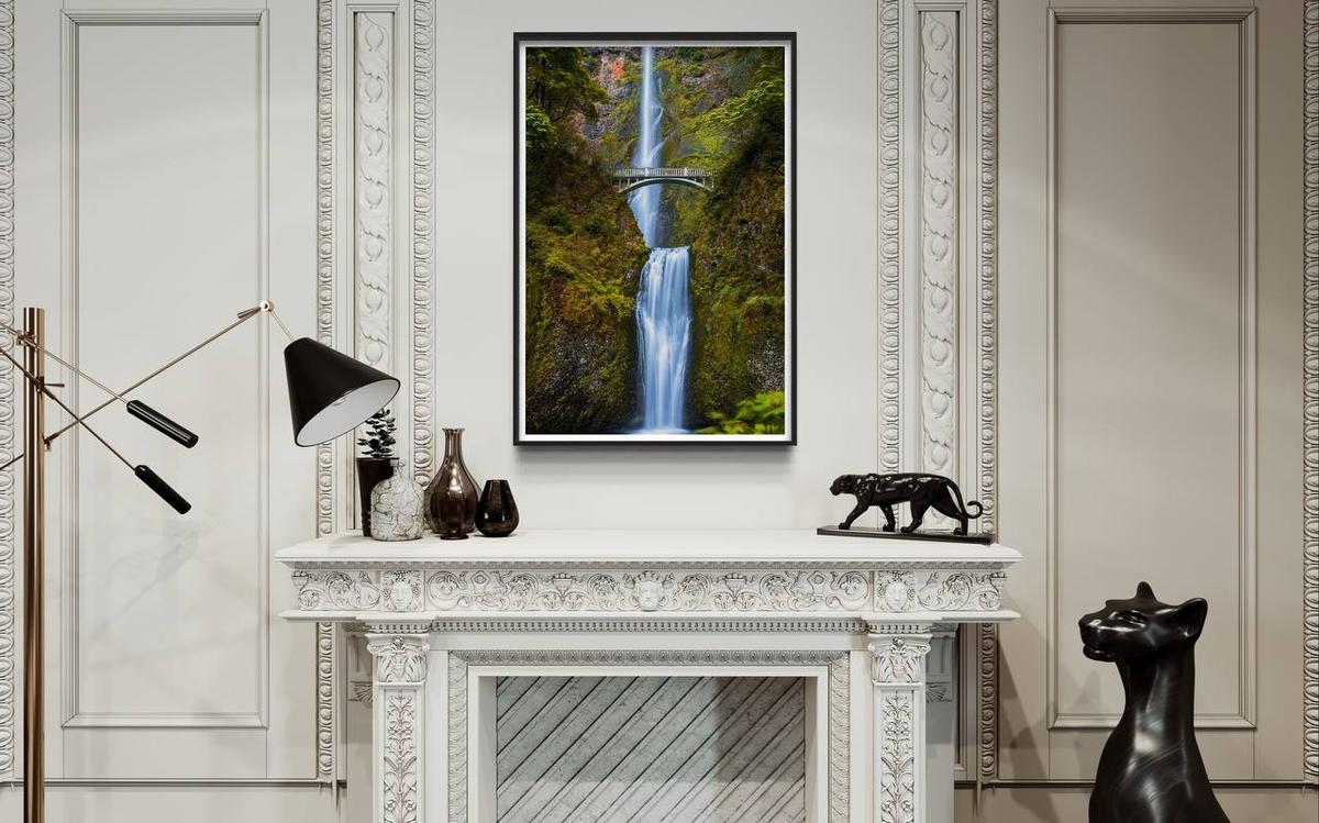
Multnomah Falls is the undisputed crown jewel of the Columbia River Gorge. Standing at a staggering total height of 620 feet, it is the tallest waterfall in the state of Oregon and attracts over two million visitors a year, making it one of the most visited natural recreation sites in the entire Pacific Northwest.
Unlike a single sheer drop, Multnomah is a classic two-tiered plunge waterfall formed by ancient, overlapping Columbia River basalt flows. The river first makes a massive, thundering leap of 542 feet down a vertical volcanic cliff face, hits a brief collection basin, drops through a turbulent 9-foot chute, then finishes with a final 69-foot plunge into a large pool right at the valley floor, passing directly beneath the eyes of visitors at the lower viewing platform. The steep cliff face exists because of the catastrophic Missoula Floods roughly 15,000 years ago — while the main Columbia River carved out the massive gorge, smaller tributary streams like Multnomah Creek couldn't erode their channels down fast enough, leaving them "hanging" high above the canyon floor.
The defining visual element that makes Multnomah instantly recognizable worldwide is the elegant Benson Bridge, a 45-foot reinforced concrete arch spanning the misty gap between the two falls. Built in 1914 by Italian stonemasons and commissioned by lumber baron Simon Benson, who gifted the bridge and surrounding land to the City of Portland, it puts you just 105 feet above the lower pool, directly in the path of the swirling mountain mist. At the base of the trail sits the Multnomah Falls Lodge, a rustic 1925 structure of native split fieldstone designed by Portland architect A.E. Doyle, housing a visitor center, restaurant, and gift shop.
According to the oral traditions of the Multnomah people, a tribe of the Chinookan nation, the waterfall was created by the Great Spirit after a young tribal princess sacrificed her own life by leaping from the cliff edge to save her village from a devastating plague. Water began flowing over the dry cliff afterward to signify that her spirit was at peace and her people were cured.
Multnomah Falls — At a Glance
- Height: 620 feet total (542-foot upper tier, 69-foot lower tier)
- Location: Columbia River Gorge, Oregon — Exit 31 off I-84 East from Portland
- Permits: Timed-Use Permit required via Recreation.gov (late May through early September, 9 AM–6 PM)
- Shuttle: Columbia Gorge Express from Portland or Cascade Locks bypasses parking entirely
- Best season: Year-round — spring for heaviest flow, fall for maple color, winter for snow and partial ice
2. Mossbrae Falls, California
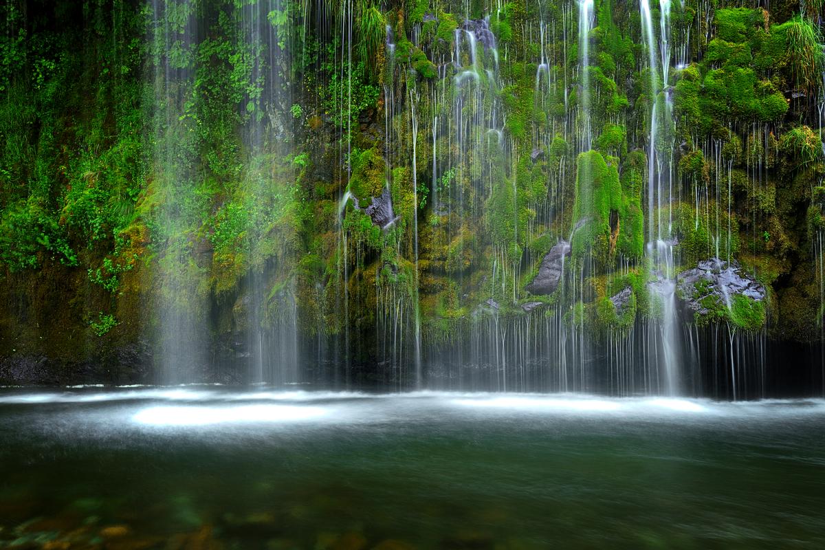
Mossbrae Falls is one of the most uniquely beautiful and ethereal waterfalls in California. Tucked inside the upper Sacramento River canyon in Dunsmuir, just south of Mount Shasta, it is famous for its distinct "weeping wall" appearance, where water erupts directly out of a moss-covered cliff face rather than tumbling over a river ledge. The falls stand roughly 50 feet high and stretch across an expansive 150-foot-wide wall of volcanic basalt.
Mossbrae is not fed by a standard surface creek. Instead, clean, subterranean springs flow from the Shasta aquifers — pristine snowmelt from Mount Shasta itself, traveling for miles through porous underground lava tubes until it reaches the sheer canyon wall of the Sacramento River. The water bursts laterally out of fractured basalt layers, weeping down in thousands of delicate, lacy ribbons. This continuous, pure water supply has coated the entire cliff face in a thick, velvety carpet of bright green moss, ferns, and wild azaleas. Rather than landing in an isolated plunge pool, the entire curtain drains directly into the edge of the rushing Sacramento River, creating a striking contrast between the calm weeping springs and the moving river water in front of them.
How to get there — and a real word of caution: Mossbrae is currently one of the most legally contentious waterfalls in California. There is no legal public land route to access it directly. The historical route — parking near Shasta Retreat and hiking roughly one mile north along an active Union Pacific Railroad track — is both dangerous and illegal. The tracks run through a narrow, winding canyon with essentially no shoulder room, and trespassing citations from Union Pacific and Dunsmuir law enforcement frequently exceed $500. The City of Dunsmuir and the Mount Shasta Trail Association have been working on a legal pedestrian bridge from the nearby Hedge Creek Falls trail system that would bypass the tracks entirely — worth checking current status before planning a visit. Photographers who view the falls safely from the river level, often via watercraft or wading upstream, get the best vantage without the legal risk.
Best time to photograph: a bright overcast day or the late afternoon, when the deep canyon falls into open shade. Direct sunlight slicing through the canopy creates harsh, high-contrast highlights on the white water that a flat, even light avoids entirely. A wide-angle lens (16–24mm) from the opposite bank captures the full 150-foot span, and a circular polarizer cuts the glare off the wet moss and river surface. It used to be my favorite waterfall on this entire coast, before I found some of the others further down this list — it still holds a special place for me.
3. Rainbow Falls, California
Rainbow Falls is the highest and most spectacular waterfall in the Eastern Sierra, located along the Middle Fork of the San Joaquin River just outside Mammoth Lakes within Devils Postpile National Monument. It makes a sheer vertical plunge of 101 feet over a dark volcanic cliff face composed of rhyodacite — a finer-grained, higher-silica volcanic rock than the basalt columns the nearby Devils Postpile is famous for, formed by lava flows roughly 75,000 to 100,000 years ago.
The falls earned their name from the rainbows that regularly slice through the heavy plume of mist at the base — the best window to see this is midday, between 11 AM and 1 PM, when the high summer sun hits the rising mist at exactly the right angle to fracture the light into a full spectrum. The waterfall is also slowly migrating upstream: the river constantly undercuts the weaker rock at the base of the falls, causing the upper lip to collapse over time and carve a deepening canyon in its wake.
This entire area came close to being industrialized out of existence. In 1910, a mining company applied to blast the site for a hydroelectric dam that would have permanently dried the river channel. Conservationists lobbied successfully, and in 1911 President William Howard Taft signed the proclamation establishing Devils Postpile National Monument, protecting the falls and the basalt columns for good.

How to get there: during peak season (mid-June through September) most visitors must park at the Mammoth Mountain Main Lodge and ride the mandatory Reds Meadow Shuttle. From Shuttle Stop #9, it's a flat 1.4-mile walk to the falls through open landscape still recovering from the 1992 Rainbow Fire — bring sun protection, there's no shade. From Devils Postpile (Shuttle Stop #6), a more scenic 2.5-mile route connects through the Ansel Adams Wilderness. Wooden overlooks at the rim give a sweeping eye-level view of the drop; a long stone staircase descends further to the riverbank for photographers who want to set up right in the splash zone.
Best time to photograph: summer only — the access road and shuttle system close for winter and don't reopen until conditions allow. Midday for the rainbow effect specifically; early morning or late afternoon for softer overall light on the canyon walls.
4. Lower Lewis Falls, Washington
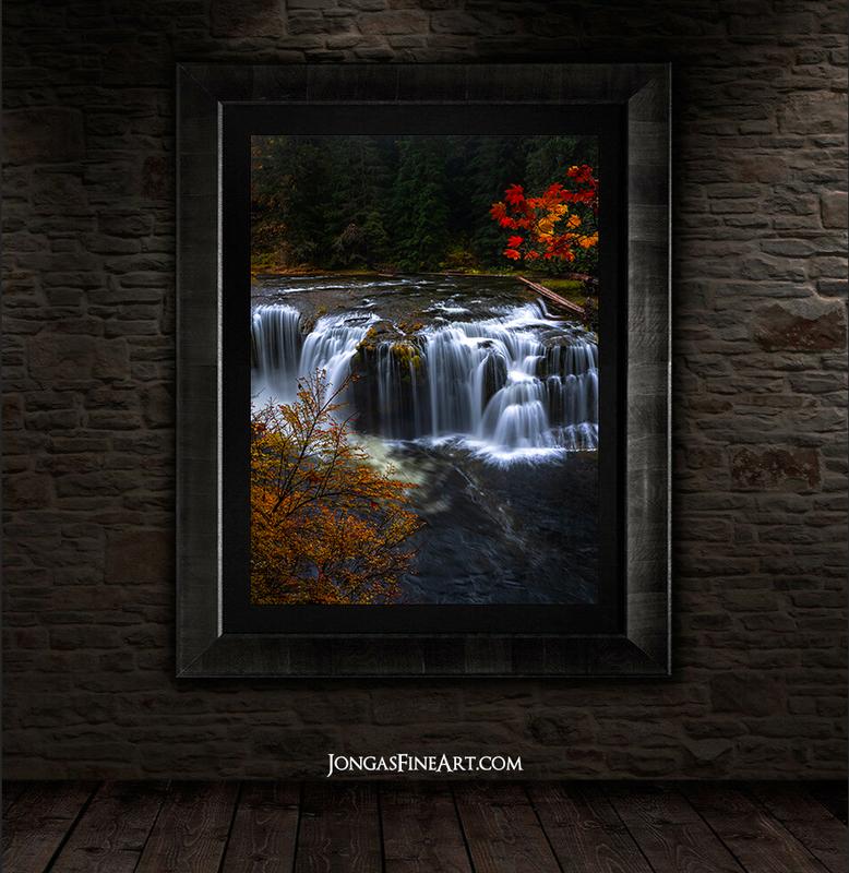
Lower Lewis Falls is the crown jewel of the Gifford Pinchot National Forest in southwestern Washington, fed by the glacier-fed Lewis River. What makes it spectacular is its breadth rather than its height — at a modest 50 feet tall, it stretches across a massive 200-foot-wide shelf of dark volcanic basalt that has eroded into a series of jagged, terraced steps. This causes the river to fracture into dozens of separate channels, bridal veils, and roaring plumes draped across the entire canyon width, all emptying into a vast, deep, emerald-green plunge pool framed by mossy rock walls and old-growth Douglas firs.
In summer, the falls become a legendary wilderness swimming hole — flat basalt shelves near the base offer resting spots, and adventurous swimmers cross the deep pool to stand on the rocky recesses directly behind the falling curtains. In October, the surrounding bigleaf and vine maples turn gold, orange, and fiery red against the dark basalt and white water, making it one of the best fall photography destinations on this entire list.
"Water is the oldest thing on this planet — a river or a waterfall is that ancient truth in constant motion, and that is exactly why standing in front of one does something to people that standing in front of almost nothing else does."
The waterfall anchors the larger Lewis River Trail (#31), and a relatively easy 7.5-mile round-trip hike connects it upstream to Middle Lewis Falls (a broad 30-foot drop) and Upper Lewis Falls (a dramatic 58-foot block plunge through a tight basalt canyon).
How to get there: via the winding forest roads of Forest Road 90. Between June 15 and September 30, the Forest Service requires a mandatory pre-paid vehicle reservation through Recreation.gov to park at the day-use area — standard forest passes are accepted for the fee but the specific parking slot must still be booked in advance, since there's no cell service in the canyon to buy one on arrival.
Best time to photograph: fall is my personal favorite here for the maple color against the white water. Washington rain is the real consideration generally — better to time a visit for a dry stretch if you plan to get down to the water's edge.
5. Middle Falls, McCloud River, California
Middle Falls is the most celebrated of the three major waterfalls along the Upper McCloud River in the Shasta-Trinity National Forest, fed by pristine snowmelt and glacial runoff from Mount Shasta. It drops 40 to 50 feet, but its defining feature is its width — nearly 100 feet of curtain-like flow sheeting over a broad, flat shelf of volcanic basalt into a deep, teal-colored pool. Middle and Upper Falls together act as a natural barrier that has isolated the upper river's aquatic life from the main Sacramento River basin for millennia, making the waters above home to the McCloud River Redband Trout, a rare native subspecies found nowhere else.
One of the most distinctive features at the base of the falls is the abundance of Indian Rhubarb, a native perennial that thrives in the constant spray zone. In spring, pink-to-white flower clusters erupt directly from the rocky cracks before any leaves appear. By midsummer the plant has grown enormous umbrella-shaped leaves up to two feet across, lining the water's edge. By October those leaves turn copper, red, and gold, making Middle Falls a genuine destination for autumn photography. The plant also holds ethnobotanical value for the region's Wintu people, who traditionally harvested and ate the peeled leaf stalks.
The McCloud River watershed is the ancestral homeland of the Winnemem Wintu and other Northern Wintu groups, and the river and its falls have served as sacred ceremonial space for thousands of years.
The tradition I have personally witnessed: a local tribe near Mount Shasta performs a rite of passage here in which young members jump from a ledge roughly 40 feet above the pool below. I have been shooting at these falls when this was happening, and watched it unfold — it is a genuinely powerful thing to witness, an active living tradition rather than something staged for an audience.
How to get there: via the McCloud River Three Falls Trail, a relatively flat path connecting Lower, Middle, and Upper Falls. A paved overlook near the parking area gives a panoramic view from above; a switchback trail descends to the canyon floor and the edge of the plunge pool where the Indian Rhubarb grows.
Best time to photograph: summer, when the falls are busiest with swimmers and the surrounding forest is at its fullest green — or October, for the rhubarb color along the banks. The pool itself runs cold year-round regardless of air temperature.
6. Palouse Falls, Washington
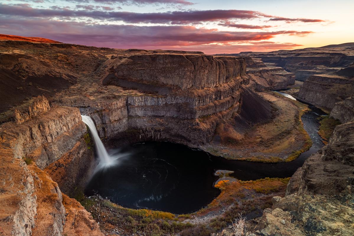
Palouse Falls is one of the most geographically striking and historically significant natural landmarks in the Pacific Northwest, dropping a dramatic 198 feet into a massive plunge pool before twisting through a winding gorge of columnar basalt toward the Snake River. The canyon was carved 13,000 to 15,000 years ago by the Missoula Floods — periodic ruptures of an ice dam holding back Glacial Lake Missoula that unleashed raging torrents across eastern Washington, eroding through millions-of-years-old flood basalt to rapidly carve the 5-mile canyon leading up to the falls. The site played a real role in the history of geology itself: scientist J Harlen Bretz used the oversized scale of this canyon and plunge pool as key evidence for his once-controversial theory of catastrophic glacial flooding.
The waterfall holds deep sacred value for the Palouse (Palus) people, whose largest traditional village once stood a few miles downstream at the confluence of the Snake and Palouse Rivers. According to Palus oral tradition, the jagged canyon walls and the vertical claw-mark fractures visible in the basalt cliffs were formed during an epic battle between a giant legendary Beaver, Wishpushya, and five Wolf Brothers. The Beaver was mortally wounded at the falls — originally known as Aputaput, meaning "Falling Water" — and its thrashing carved out the canyon as it died.
In March 2014, Palouse Falls was officially declared the state waterfall of Washington, a designation won through a successful lobbying campaign by local elementary school students from nearby Washtucna.
Palouse Falls — At a Glance
- Height: 198 feet into a massive basalt plunge pool
- Location: Palouse Falls State Park, eastern Washington
- Viewpoints: Lower viewpoint, intermediate interpretive path, and elevated Fryxell Overlook
- Safety: Unprotected canyon edges drop several hundred feet — maintain real distance from unfenced rims
- Best season: Spring for peak flow; deep winter for dramatic ice formations on the cliff face
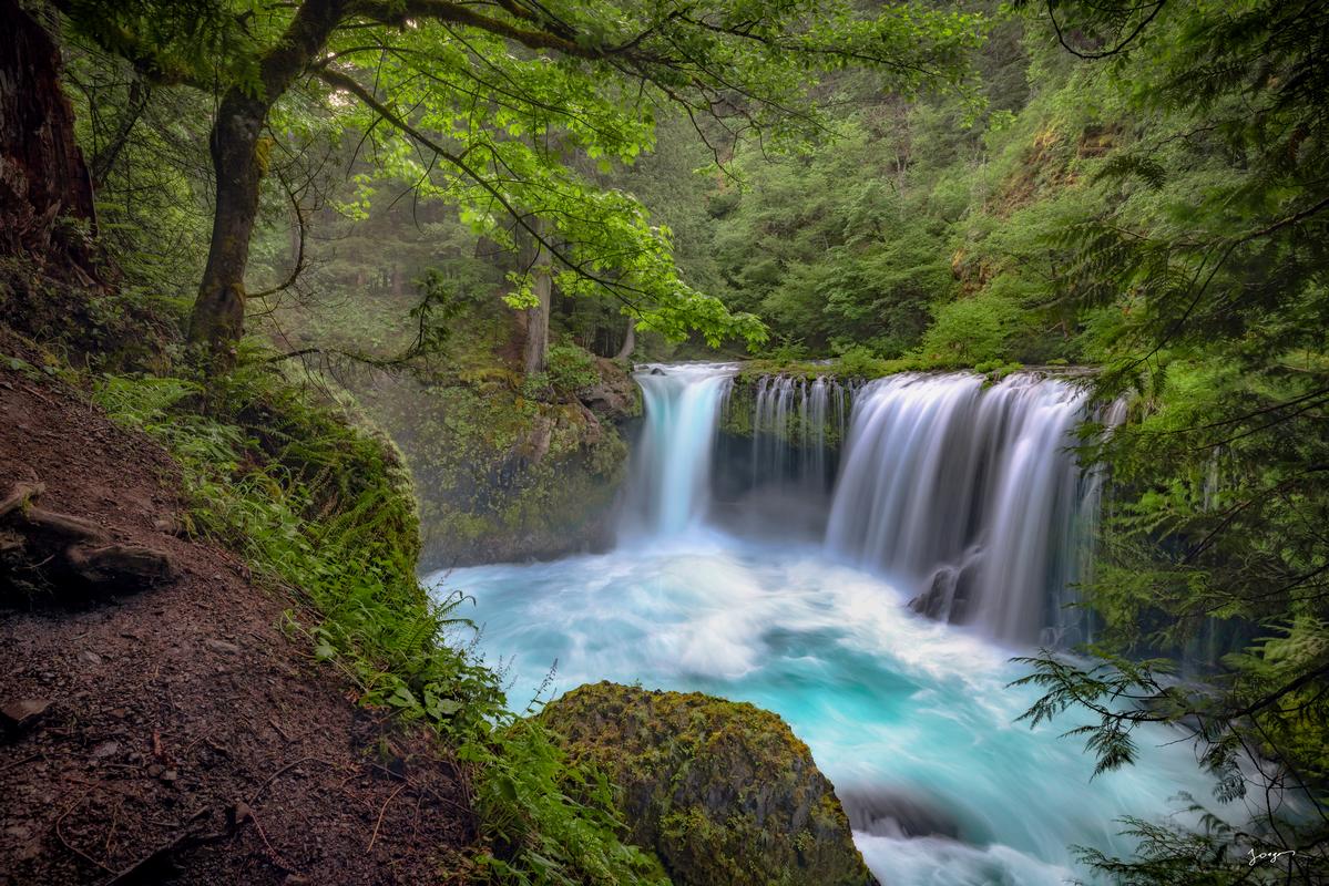
7. Spirit Falls, Washington
Spirit Falls is legendary among Pacific Northwest landscape photographers and extreme whitewater kayakers alike, located along the wild Little White Salmon River in Skamania County. It drops approximately 33 feet over a horseshoe-shaped ledge into a churning pool, and its most mesmerizing characteristic is the brilliant turquoise-to-aqua hue of the water — caused by the combination of cold, pristine mountain springs and volcanic aquifers surrounding Mount Adams, plus the intense aeration from upstream rapids, which introduces millions of tiny air bubbles that scatter light toward those intense blue and green wavelengths once the water hits the plunge pool.
Among kayakers, Spirit Falls is considered a world-class, rite-of-passage drop on a stretch of river rated continuous Class V+. Paddlers aim for a specific "boof" stroke off the center or right-center to clear the violent hydraulic undertow at the base, and the rapid immediately below the falls — known, accurately, as "Chaos" — adds a second layer of danger that keeps this drop reserved for elite, expert paddlers only.
How to get there — and the honest access situation: the hike to the falls is short, under a mile round trip, but exceptionally steep, dropping roughly 500 vertical feet down a loose field of talus and fractured basalt. Good footwear is mandatory. Land ownership around the falls is a genuine patchwork of public forest and private parcels, including timber company and conservation group land, and access routes and roadside parking near Cook-Underwood Road have shifted over the years due to boundary disputes and safety enforcement — current local signage should always be checked before a visit, and at points the unofficial trail has been closed entirely. For most people, viewing Spirit Falls happens either as a kayaker running the river or as a distant view from points along the canyon rim.
Best time to photograph: overcast days or the blue hour. Direct midday sun washes out the deep aqua tones and creates harsh reflections on the wet basalt, while soft ambient light lets the turquoise saturation of the pool take center stage.
8. Toketee Falls, Oregon
Toketee Falls is widely considered one of the most structurally perfect waterfalls in the Pacific Northwest, tucked deep within the Umpqua National Forest in southern Oregon. Its defining feature is the gorge of columnar basalt that frames it — massive, vertical hexagonal and pentagonal pillars formed thousands of years ago when slow-cooling, thick basaltic lava flows contracted and fractured into remarkably uniform columns, creating an almost architectural frame around the falling water. The word "toketee" is Chinook Jargon for "graceful" or "pretty," and it fits.
The North Umpqua River drops a total of 113 feet across two tiers: an upper drop of 28 feet into a pool mostly hidden from the main overlook, followed by a clean, powerful 85-foot vertical curtain into a large pool of vibrant teal and translucent blue. Because the North Umpqua is heavily regulated by upstream reservoirs and springs, Toketee maintains an exceptionally stable, year-round flow — unlike most waterfalls on this list, it does not noticeably dry up by late summer. Part of that regulation comes from a striking piece of mid-century engineering just upstream of the trailhead: a 12-foot-diameter wooden pipeline, built in 1949 as part of the North Umpqua Hydroelectric Project, that diverts a portion of the river to a downstream powerhouse.
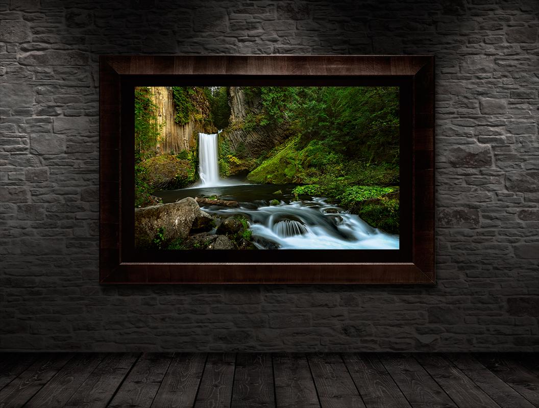
How to get there: from Highway 138 (the North Umpqua Highway) east of Roseburg, turn at milepost 58.6 onto Forest Road 34, cross the first bridge, and the trailhead parking is on the left. The hike is a short, scenic 0.8-mile round trip through old-growth Douglas fir, red cedar, and Pacific yew, ending at a sturdy multi-tiered viewing platform with a clean, eye-level frame of the lower 85-foot plunge.
Best time to photograph: because the deep, narrow canyon keeps the falls shaded much of the day, Toketee is excellent for long-exposure work even in bright conditions — a circular polarizer or neutral density filter brings out the saturated teal of the pool and the dark, wet basalt. Because the flow stays consistent year-round, this is one of the more reliable shoots on this entire list regardless of season; fall brings the added bonus of color in the surrounding old-growth canopy.
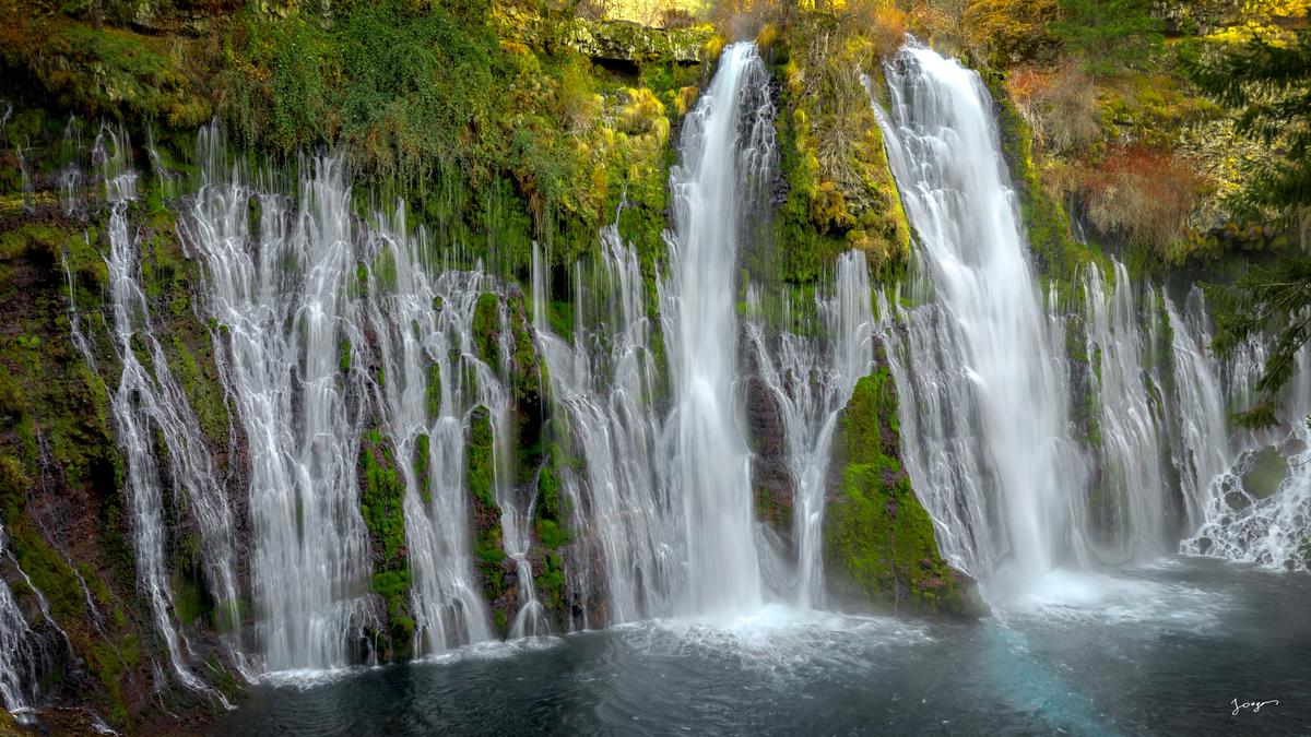
9. Burney Falls, California
Burney Falls is widely considered one of the most breathtaking waterfalls in North America, once described by President Theodore Roosevelt as the "Eighth Wonder of the World." Located within McArthur-Burney Falls Memorial State Park in Shasta County, it stands 129 feet tall, but its real distinction is where the water comes from. Unlike most waterfalls relying on a river flowing over a single cliff edge, Burney is fed almost entirely by underground aquifers and springs. At the top, Burney Creek spills over a basalt lip in two main plunges. Below that, the rock face is composed of porous, fractured basalt layered over an impermeable stratum of older volcanic ash — millions of gallons of snowmelt absorbed high on Mount Shasta and the Lassen peaks travel for miles through underground lava tubes and erupt directly out of the solid rock as a vast, lace-like wall of weeping springs. Because this underground reservoir acts as a natural pressure regulator, Burney maintains a stable flow of roughly 100 million gallons a day, year-round, even through peak drought.
The falls and surrounding volcanic basin are the ancestral lands of the Ilmawi band of the Pit River Tribe (Achomawi), for whom the site has been a sacred spiritual center and ecological crossroads for millennia. The constant mist creates a hyper-humid microclimate at the pool's edge, often 10 to 15 degrees cooler than the rim, supporting thick moss and ferns and providing nesting habitat for the Black Swift, a rare bird that builds its nests on the wet, mossy shelves directly behind the falling water.
The practice I have personally witnessed here: on one visit, I watched a local religious group perform what was unmistakably a baptism-style ceremony in the pool below the falls — full immersion in the cold spring-fed water, conducted with the same reverence I have seen attached to formal Christian baptism elsewhere. Whatever the specific tradition, the instinct to use this particular water for a moment of spiritual renewal was completely unmistakable.
How to get there: off Highway 89 about 60 miles northeast of Redding, between Mount Shasta and Lassen Peak. A short paved trail leads from the main parking lot to a spectacular front-on overview, while a longer 1.2-mile loop descends to the canyon base and crosses footbridges over Burney Creek above and below the falls.
Best time to photograph: bright overcast days or early morning, when the canyon is bathed in uniform, soft ambient light. Because the falls face roughly north-northeast inside a bowl, direct midday sun creates harsh, blown-out highlights on the white water and heavy shadow on the dark basalt — the flat light brings out the deep blues and forest greens far better. Because the flow is spring-fed and barely changes with the seasons, Burney is reliably good any time of year.
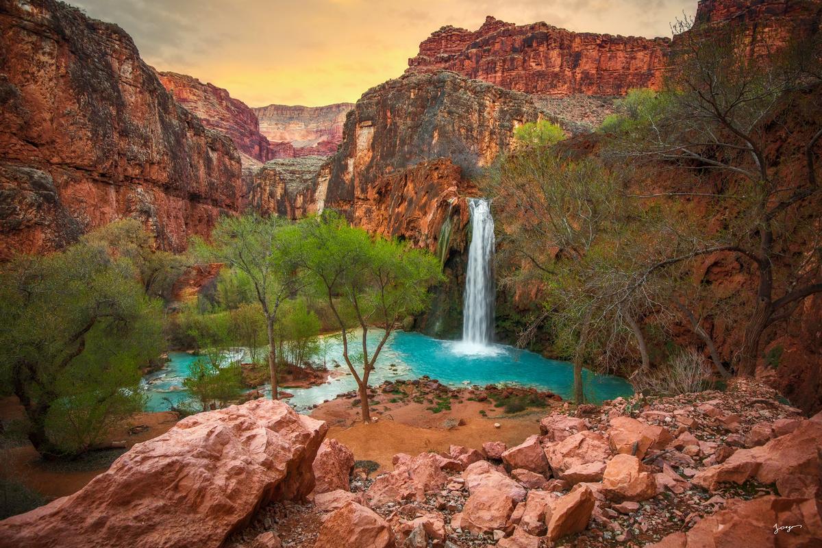
10. Havasupai Falls, Arizona
Havasupai Falls — more precisely Havasu Falls, part of a larger series including Mooney Falls and Beaver Falls — is one of the most visually surreal natural wonders on Earth, tucked inside a side branch of the Grand Canyon. The otherworldly turquoise color of Havasu Creek is real geochemistry, not a filter: the water originates in a massive underground limestone aquifer, and as it filters through that limestone over decades it dissolves enormous amounts of calcium carbonate and magnesium. When the mineral-rich water emerges into the desert sun, carbon dioxide escapes and forces the calcium carbonate to precipitate out as microscopic suspended crystals that scatter light into that brilliant, opaque aqua-blue. The same process coats every fallen log and rock in smooth white travertine, which over centuries builds into the terraced pools and dams that constantly reshape the creek.
The waterfall sits entirely on the Havasupai Indian Reservation, not within Grand Canyon National Park itself. The Havasupai Tribe — whose name translates to "people of the blue-green water" — has lived in, farmed, and protected this canyon for over 800 years. Supai Village, two miles upstream of the main falls, is one of the most remote communities in the United States, sitting at the bottom of a 3,000-foot canyon with no road access — all mail and supplies arrive by helicopter or mule train.
Havasu Falls drops a sheer 100 feet over Supai Group sandstone and was historically known as Bridal Veil Falls for the wide, elegant sheet it once formed across the entire rock face. Major flash floods in 1993, 2008, and subsequent seasons tore away sections of the upper travertine lip and channeled the river into the single, concentrated plume seen today, sculpting entirely new travertine terraces overnight in the process.
Of every waterfall on this list, Havasupai is the most magical, and it is not close. The combination of that turquoise water against red Navajo sandstone, in heat that regularly tops 100 degrees Fahrenheit, creates something that genuinely feels like a desert paradise — an environment that should not exist in that landscape and somehow does. It is no surprise this is the most famous waterfall on this entire list, and that every annual permit sells out within a single day.
How to get there: permits go on sale February 1st each year through a competitive online lottery and sell out almost immediately, requiring a minimum three-night stay at the campground. Day hiking is strictly illegal. Reaching the campground requires a grueling 10-mile hike one-way (20 miles round trip) starting at Hualapai Hilltop, dropping down steep switchbacks into an exposed, shadeless gravel wash — or, for those willing to pay roughly $150 one way, a helicopter flight that cuts the trip to a few minutes. Reservations and full details are available directly through the tribe at havasupaireservations.com.
Best time to photograph: mid-morning or late afternoon, when direct sun has left the canyon floor. The deep canyon walls act as a massive natural softbox, but shooting in the middle of a sunny day creates harsh, blinding glare on the reflective white travertine — the off-peak light lets the cool blue water and glowing red rock achieve a natural balance.
What All of These Have in Common
Every waterfall on this list looks different depending on when you arrive. Spring brings the strongest flow almost everywhere, fed by snowmelt working its way down from the mountains above, and the surrounding landscape is at its greenest in that same window. By the time autumn arrives, most of these falls have thinned considerably as the snowmelt runs out, but the forests around them have turned gold and red, and photographs from the exact same spot look like an entirely different season, an entirely different place. I have swum in nearly every waterfall on this list — Mossbrae, Rainbow, Lower Lewis, Middle Falls, Burney, Havasupai — with the two exceptions being Multnomah, where it is neither practical nor advisable given the terrain, and Palouse, where the hydraulics at the base are genuinely dangerous regardless of how inviting the water looks from the rim.
What I keep coming back for, beyond the photographs, is the thing I described at the start: the specific feeling of standing next to a large volume of moving water and sensing, even without being able to fully explain it, that you are in the presence of something older and truer than almost anything else available to stand in front of. Landscape photography exists, in part, to bring a piece of that feeling home with you. These ten places are where I go to find it, again and again, regardless of how many times I have already been.
Explore the Jongas Waterfall Photography Collection →
Explore Landscape Photography Prints →
Explore California Photography →
Eddie Jongas is a modern fine art photographer based in Las Vegas, Nevada, who has personally visited and photographed every waterfall on this list, most of them many times over. His TruLife acrylic-mounted limited edition prints are available exclusively through jongasfineartphotography.com. Free shipping to all 50 states.
