Let me tell you about a place that has a giant ancient rock, sea otters floating on their backs cracking open clams, a harbor full of fishing boats, 400-year-old trees that are only six feet tall, and cliffs so wild they look like they belong on another planet. That place is Morro Bay, California, and it is one of my favorite spots on the entire West Coast.
I have been coming here for years to take photographs. Every single time I show up, the place looks different. The same rock looks totally different in the morning than it does at sunset. The harbor is busy and loud at noon and completely quiet at dawn. The hills are golden in summer and bright green in spring. A waterfront that changes this much, this often, is the kind of place a photographer never gets tired of. But you do not have to be a photographer to love Morro Bay. You just have to show up and pay attention.
Here is everything you need to know.
The Rock — A 23 Million Year Old Giant
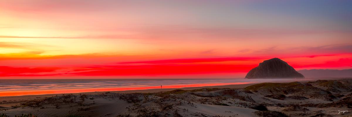
The first thing you see when you drive into Morro Bay is the Rock. It is hard to miss. It is a 576-foot-tall volcanic plug sitting right at the entrance to the harbor, like someone dropped a giant stone cone into the ocean and forgot to pick it up. Which, more or less, is exactly what happened — except instead of someone dropping it, a volcano pushed it up through the earth about 23 million years ago and then slowly eroded away around it over millions of years, leaving just this massive dark rock standing by itself at the edge of the Pacific Ocean.
The rock has a name that goes back thousands of years. The Chumash people, who lived here long before anyone else, called it Lisamu. The Chumash were incredible people. They built plank canoes called tomols out of wood planks sewn together with plant fiber and sealed with tar, and they paddled them through the bay and out into the open ocean to fish. These canoes were so well built that modern Chumash people have brought the tradition back and still build and paddle them today.
The Chumash considered Lisamu a sacred place. They did not just think of it as a big rock. They thought of it as a place where the ordinary world and the spiritual world came together. And that belief has led to one of the more interesting and complicated legal battles in the recent history of this area.
The rock is a protected State Historical Landmark, and California State Parks officially prohibits climbing it — partly to protect the nesting peregrine falcons on the upper cliffs, and partly because it is a historical monument. But California State Parks has also allowed the Salinan people, a separate indigenous tribe whose ancestral territory includes this stretch of the coast, to climb the rock twice a year for ceremonial purposes — once during the summer solstice and once during the winter solstice. The Salinan people call the rock Lesa'mu and have practiced this tradition for generations and consider the climbs an essential part of their spiritual life.
The Chumash filed a lawsuit over this arrangement. Their argument is that the rock sits within their ancestral homeland — the Chumash people called it Lisamu, after all — and that allowing the Salinan to climb it for ceremonies while blocking the Chumash from doing the same is not fair. It is, at its core, a dispute between two indigenous groups over which tribe has the stronger ancestral and spiritual claim to the same sacred site, with the California state government caught in the middle trying to figure out how to handle it.
The whole situation is a reminder that Morro Rock has never stopped being contested ground. It was fought over by the Spanish, blasted apart by engineers for 80 years, occupied by the military, and now it is at the center of a genuine legal argument between tribes and the state about who gets to use it and how. The rock absorbs all of it and goes nowhere.
In 1542, a Portuguese explorer named Juan Rodríguez Cabrillo was sailing along the California coast when he spotted the rock from his ship. He named it El Morro, which is a Spanish word for a rounded hill or headland. That name stuck. For the next few hundred years, Spanish ships sailing up and down the California coast used the rock the same way sailors use a lighthouse — as a landmark to figure out where they were.
Wait, the Rock Used to Be an Island?
Here is something that blows most people's minds when they find out. The road you drive on to get to the base of the rock? That used to be the bottom of the ocean.
Morro Rock was originally surrounded by water on all sides. It was a real island. The bay had two separate channels flowing around it, and the only way to get to the rock was by boat. That meant the harbor was really hard for fishing boats to navigate, because the water was always shifting and the sand kept moving around in unpredictable ways.
In 1935, the government decided to fix the problem. Using money from two Depression-era programs called the Public Works Administration and the Works Progress Administration, engineers built a giant 1,500-foot rock wall across the northern channel of the bay. That wall permanently closed off one of the two channels, filled in with sand and silt over time, and created a solid road connecting the mainland to the base of the rock. The road you drive on today is that wall.
Then during World War II, the U.S. military set up an Amphibious Training Base at Morro Bay. They needed the harbor to be safe from giant ocean waves so they could train sailors on landing boats. So the Army Corps of Engineers built a massive breakwater — a long wall of rock sticking out from the south side of Morro Rock into the open ocean. And here is the wildest part: to build all of these walls and breakwaters, they used rocks blasted from Morro Rock itself. From 1889 all the way to 1969 — that is 80 years — workers kept dynamiting pieces off the rock to use as building material. The flat, angular face on the south side of the rock that does not look natural? That is 80 years of blasting. The rock you see today is only about two-thirds of its original size.
A man named Major Harold Guyon finally got them to stop. He was a retired Army officer who spent decades telling anyone who would listen that they needed to quit blasting the rock. He pushed and pushed until the state declared it a protected historic landmark in 1968, and Congress officially banned all quarrying in 1969. Because of him, the rock is still there.
The People Who Built the Town
A man from Ohio named Franklin Riley showed up in California during the Gold Rush. He tried mining for a while, then looked at the Morro Bay area and had a better idea. The valley behind the bay was filling up with farms and cattle ranches and dairy operations. All those farms needed a way to ship their butter and cheese and cattle hides to other places. Riley realized the natural harbor could be a perfect shipping port.
In 1870, Riley officially founded the town of Morro Bay. He built the first dock on what is now called the Embarcadero — the famous waterfront area — and donated land for the town's first school and church. He basically invented the town out of a good idea about geography.
The dairy farms he was counting on were mostly run by the Stocking family — brothers named Elijah and Jasper — and by Swiss and Italian immigrants who recognized that the cool, foggy Central Coast climate was perfect for dairy farming. Their farms produced so much butter and cheese that Riley's dock stayed busy for years.
Then fishing took over. A man named Walter Stewart built processing plants on the waterfront and turned Morro Bay into the abalone capital of the world. Abalone are large sea snails with shells that look like ear-shaped rocks and meat that was considered a delicacy. During the 1940s and 1950s, fishermen and divers came from all over California to work in Morro Bay's abalone industry. It was one of the most famous fishing ports on the entire Pacific Coast.
And then there was William Randolph Hearst. If you have driven along the coast a little further north, you may have seen his famous castle at San Simeon — a massive mansion on a hilltop that looks like it belongs in Europe. Hearst had also bought a huge amount of land around Morro Bay, including the long sandspit that protects the harbor from ocean waves. In the 1930s, he made a deal with the state of California: he would give them the sandspit and the surrounding land in exchange for other properties he wanted somewhere else. That deal created Morro Bay State Park — 2,500 acres of protected land that has never been developed. It is one of the best things that ever happened to Morro Bay, and it happened because a very rich man decided to trade.
The Weather — Why Morro Bay Has Its Own Personal Climate
Here is something I notice every single time I drive up to Morro Bay from Los Angeles in the summer. I leave home when it is hot. I drive north on the 101 and the coast stays cool all the way through Ventura, Santa Barbara and Gaviota. Then I go inland a little around Solvang and the Santa Ynez Valley and it gets hot — real summer hot, like stepping into an oven. Then Pismo Beach cools things back down. Then San Luis Obispo warms up again. And then I come around the last set of hills and drop into Morro Bay and suddenly it is 67 degrees, there is a low grey blanket of cloud sitting right over the water, and I am reaching for the sweatshirt I left in the back seat.
Every time. No matter how hot the rest of California is.
The reason is the marine layer. Morro Bay sits at a place on the coast where the cold water of the deep Pacific Ocean comes very close to shore. When the air inland gets hot in summer — and it gets really hot, we are talking 100 degrees in Paso Robles just 30 miles east over the mountains, 110 degrees in Fresno and the Central Valley in July and August — that hot air rises. The cold ocean air rushes in from the Pacific to replace it. And as it comes in, it brings the marine layer with it: a thick, low blanket of cool fog that sits right over the coast and keeps temperatures gentle even on the hottest days of summer.
"Morro Bay in August, when the rest of California is sweltering, is often sitting at 68 or 70 degrees with a light grey sky and a breeze off the water cold enough to make you zip up your jacket."
The result is that Morro Bay in August, when the rest of California is sweltering, is often sitting at 68 or 70 degrees with a light grey sky and a breeze off the water cold enough to make you zip up your jacket. People who live in Paso Robles and Fresno and the Central Valley know this better than tourists do. On a summer weekend when the temperature in the valley hits 105, those people get in their cars and drive west over the mountains to Morro Bay just to cool down and eat some fresh seafood while they're at it.
This also means that packing for Morro Bay in summer requires a little thought. Do not assume that California in July means shorts and flip-flops all day. Bring a light jacket or a hoodie. The mornings here are almost always cool and foggy, even in August. The afternoon sometimes clears up and warms into the low 70s, and sometimes it does not clear at all and stays grey and 65 the entire day. If you are coming from somewhere hot and you left your warm layers at home, you will be cold and slightly jealous of everyone who brought a sweatshirt.
For photographers, the marine layer is not a problem — it is an opportunity. Overcast light is soft, even, and directionless, which is exactly the kind of light that brings out the deep teal of the harbor water, the texture in the wet sand, and the dark basalt of the rock without blowing out the highlights or creating harsh shadows. Some of my favorite photographs from Morro Bay were made on grey, overcast mornings when the marine layer was sitting low over the harbor and the light was doing something quiet and moody that clear-sky sunshine never produces. If you show up and it is foggy, do not be disappointed. Get your camera out.
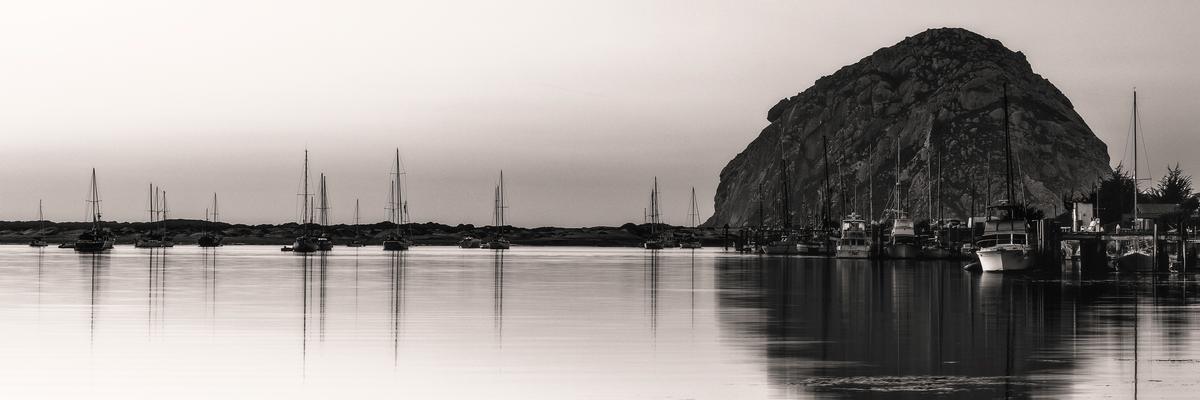
The Embarcadero — The Heartbeat of the Town
The Embarcadero is the waterfront. It is a long stretch of docks and buildings running along the edge of the harbor, and it is one of the best boardwalks in California because it is a real working waterfront, not a fake one built for tourists.
Real fishing boats come and go from these docks. Real fishermen unload real fish that they caught that morning. You can smell the salt water and the engine diesel and the fish being prepared in the restaurants nearby, and it all mixes together into a smell that is specific to this place and no other place.

The Embarcadero is also where you will find the sea otters. Morro Bay has one of the largest groups of southern sea otters on the California coast, and they live right in the harbor. They float on their backs in the water, using their chests as tables to crack open clams and mussels. They carry a small rock on their chest that they use as a hammer. They wrap themselves in kelp to keep from drifting while they sleep. They are, completely objectively, the most entertaining animals in California, and you can watch them from the dock or while eating your meal and listening to live music at an outdoor restaurant.
The best place to eat on the Embarcadero is called Tognazzini’s Dockside Too. It is a fish shack built on wooden planks right above the working dock. You sit outside, the fishing boats are pulling in right next to you, pelicans are working the water below, and the fish on your plate was caught that morning by people you can literally see from where you are sitting. There is no better fish and chips on the Central Coast and they serve the freshest scallops you can find.
If you want a nicer dinner, Windows on the Water is a restaurant with a view directly over the harbor. The oysters come from the bay itself — Morro Bay has oyster farms growing in the water right outside the window. Watching the sunset from here, with the rock going dark against the sky, is the kind of view that makes people want to move to California.
The Estuary — Where the Ocean Meets the Land
Behind the harbor, spreading out across the flat land between the water and the hills, is the estuary. An estuary is a place where a bay or harbor connects to rivers and creeks and creates a shallow, protected body of water that is partly salty from the ocean and partly fresh from the streams. Estuaries are some of the most important places in the natural world. They are nurseries for fish, feeding grounds for birds, and home to all kinds of plants and animals that need that specific mix of salt and fresh water to survive.
Morro Bay is one of only 28 National Estuaries in the United States. That means the government has officially recognized it as one of the most important natural water systems in the country. The reason it earned that designation is the sheer number of species that depend on it. Hundreds of species of birds use it during migration — some of them flying from Alaska to South America and stopping at Morro Bay to rest and feed along the way. The eelgrass beds in the shallow parts of the back bay are nurseries for young fish. And the same sea otters you see floating in the harbor come into the shallower back bay channels to forage for food in the morning.
Morro Bay at a Glance
- Morro Rock height: 576 feet — a volcanic plug formed 23 million years ago
- Rock quarrying period: 1889 to 1969 (80 years of blasting); rock now roughly two-thirds original size
- National Estuary status: One of only 28 designated National Estuaries in the United States
- Morro Bay State Park: 2,500 acres of permanently protected coastal land, created via Hearst land deal in the 1930s
- Summer temperatures: Typically 67–72°F at the harbor, while Paso Robles (30 miles east) hits 100°F+
- Elfin Forest trees: Coast Live Oaks standing just 6 feet tall, yet hundreds of years old
- Montaña de Oro: 15 minutes south; Valencia Peak trail 4 miles round trip, 1,347 feet elevation
- Best otter photography window: 10 AM–2 PM at the South T-Pier
The best way to understand the estuary is to go up. Black Hill, accessible through Morro Bay State Park, is a 661-foot hill with a trail to the top that gives you a view of the whole system. From up there you can also see the harbor, the rock, the long sandspit stretching south, the shallow back bay channels, the hills behind the town, and on a clear day the Santa Lucia Mountains in the distance. It takes about 45 minutes to hike up and it is worth every step.
The other way to understand it is to get on the water. You can rent a kayak or a stand-up paddleboard on the Embarcadero and paddle into the back bay channels. The water is calm enough that almost anyone can do it. You paddle over eelgrass beds. You float past herons standing in the shallows. If you are lucky, you share a channel with otters. It is the kind of morning that makes you wonder why you do not spend more time on the water.
The Elfin Forest — Trees That Forgot to Grow Up
On the south side of the bay, there is a small forest that looks like it was designed by someone who wanted to confuse visitors. The trees are Coast Live Oaks. In normal conditions, those trees grow 70 feet tall. In the Elfin Forest, they grow about six feet tall. They are gnarly and twisted and covered in lichen and moss, and they look like something out of a fairytale. If you walked through here at night with a flashlight you would definitely think something magical was going on.
The reason they are so small is the soil and the wind. The ground here is thin and nutrient-poor — basically sandy old seabed — and the constant wind off the ocean constantly dries out anything trying to grow. The trees respond by growing very slowly and very short, putting their energy into surviving rather than getting tall. The result is a forest of six-foot trees that are hundreds of years old. Some of these little twisted trees started growing before the Pilgrims arrived in America. They are older than the United States. They are just not very tall about it.
A wooden boardwalk runs through the Elfin Forest so that visitors can walk through it without trampling the roots. Early morning, when the fog is still sitting on the bay and the light comes through the twisted branches in soft filtered beams, is the best time to visit. It is completely free, there are no facilities, and it is one of the most quietly strange places on the California coast.
Montaña de Oro — Where Things Get Wild
Drive 15 minutes south of Morro Bay and everything changes completely. The calm harbor and the gentle estuary disappear and you are suddenly at the edge of some of the most dramatic coastline in California.
Montaña de Oro means Mountain of Gold in Spanish. The name comes from california poppies and other wildflowers that cover the hills every spring — great waves of yellow and orange and purple that make the whole hillside look like it is on fire with color. But the park is worth visiting any time of year, not just when the flowers are blooming.
The cliffs at Spooner’s Cove are the first thing that gets your attention. The ocean here is not the gentle, sheltered harbor water of Morro Bay. It is open Pacific, full power, crashing into fractured rock cliffs with real force. The rock itself is millions of years old — ancient seafloor that got pushed up to the surface when the Pacific Plate and the North American Plate smashed together over millions of years. You can see the layers in the cliff faces, tilted at steep angles from the pressure. The beach at Spooner’s Cove is beautiful and swimmable when the waves are small. When the waves are big, it is better to watch from the cliff above.
Half a mile south of Spooner’s Cove is Corallina Cove, where the tidepools are some of the best on the coast. A tidepool is a pool of water left behind in the rocks when the tide goes out. Inside those pools live sea anemones, sea urchins, hermit crabs, tiny fish, sea stars, and all kinds of other creatures that are usually hidden under the ocean. At a low tide in Corallina Cove, those pools are exposed and you can walk among them and look at everything living in them. The key rule: look but do not touch. The animals in tidepools are fragile, and human hands leave oils that can hurt them.
If you want to hike, Valencia Peak is the park’s main mountain. It is 1,347 feet tall. The trail is about 4 miles round trip. When you get to the top, you can see the entire sweep of Morro Bay to the north — the rock, the sandspit, the harbor, all of it laid out below you — plus miles of wild coast stretching south. It is one of the best views on the Central Coast and it costs nothing, even parking is free, except the effort of hiking up there.
For mountain bikers, Montaña de Oro is one of the rare California state parks that actually lets bikes on real trails, not just fire roads. The Hazard Peak Trail has proper singletrack that climbs through chaparral and connects to fast descents through the canyons below. If you brought a mountain bike, this is where you ride it.
Art, Photography, and the Light That Makes It All Worth It
Morro Bay has a real art scene, which makes sense because the light here does something unusual. The combination of the marine layer fog, the ocean, the rock, and the specific angle of the California sun creates conditions where everything looks slightly different here than it does anywhere else. Photographers and painters have been coming to Morro Bay for this light for a long time.
The Art Center Morro Bay shows work by local and regional artists throughout the year. The outdoor Art in the Park event, held downtown in the Morro Bay Park corner of Morro Bay Blvd and Harbor Drive, brings painters, sculptors, ceramicists, and photographers together for a few days each season in one of the most relaxed outdoor art settings you will find anywhere. I've exhibited my art in this event and offer photography workshops in Morro Bay area. If you are interested in learning how to photograph a place like Morro Bay — how to find the right light, pick the right moment, get a perfect composition and come away with images that actually capture what made you stop and look — check out the workshop information on this site.
There are many great spots to shoot Morro Rock around the area. I've shot it from almost all possible angles. You have some great spots on the north side from the dunes area, or you can take great photos from the dock on the Embarcadero, or further down from Morro Bay State Park or even on the way to Montaña de Oro. The possibilities are limitless, you just need some luck getting some clouds and a perfect sunset.
The sea otters at the South T-Pier photograph best between 10 AM and 2 PM. The overhead light at that time shines down through the teal-colored harbor water and makes the animals visible below the surface. Use the longest lens you have and stay back — the otters are wild animals and you should not get close to them. If you wait long enough, you will see one crack open a clam on its chest, which is the shot you actually want.

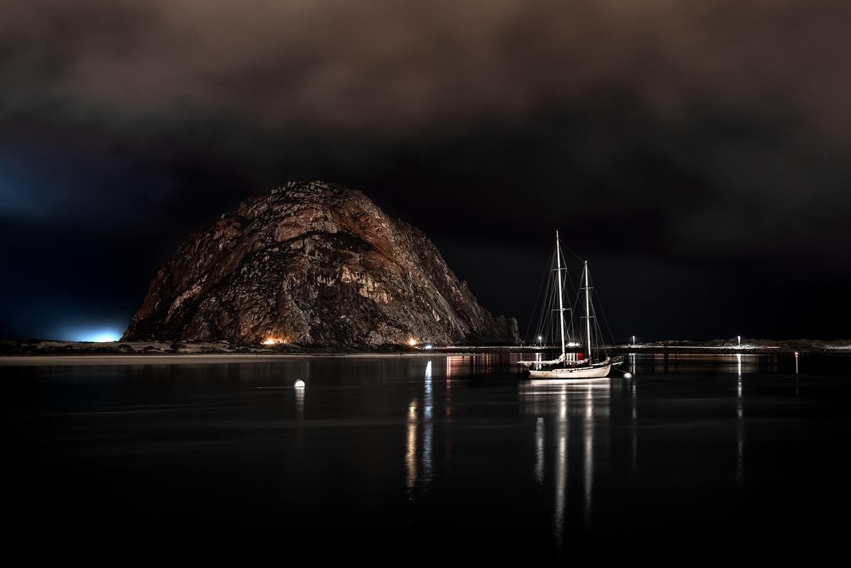
The rock at dusk, silhouetted against the western sky, is the image that makes Morro Bay look like nowhere else on Earth. Use a telephoto lens to make the rock appear large against the sky. Include something in the foreground — a fishing boat, a dock post, the wet sand — to give the rock scale. The window of best light is about 20 minutes after the actual sunset, when the sky goes deep blue and the rock goes completely black. After that it gets dark fast.
My own photographs from Morro Bay, taken over many visits in many different seasons and weather conditions, are available in the Morro Bay fine art photography collection. Each print is a limited edition, made on TruLife acrylic-mounted surface, signed and with a Certificate of Authenticity. See also the broader California photography collection for coastal work from across the state.
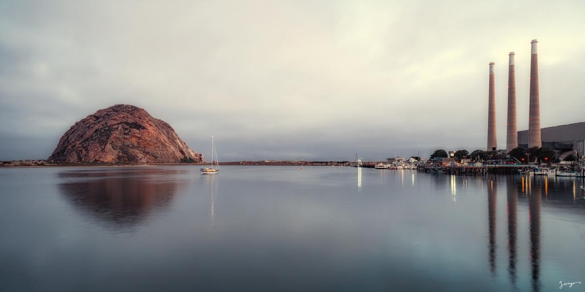
Before the Stacks Come Down
The three tall concrete stacks of the old power plant are one of the most recognizable things about Morro Bay’s skyline. They were built in the 1950s when a big electric company set up a plant on the waterfront, and they have been part of the view ever since — these tall geometric towers rising up alongside the ancient volcanic rock, completely different from each other and somehow, together, making the most unique harbor skyline in California.
The plant does not operate anymore, and the plan is to eventually tear the stacks down as part of redevelopment. When they go, the view of Morro Bay will never look exactly the same. That specific dusk silhouette — the ancient rock and the industrial towers against the same evening sky — will be gone.
That is a reason to go now. Every place has a version of this: something that makes it specifically itself right now, at this moment in its history, that will not be there in exactly this form in a few years. The stacks are coming down. The rock is not going anywhere. The sea otters will still be floating in the harbor along with sea lions. The Elfin Forest will still have its 400-year-old tiny trees. And the light over the bay every evening will keep doing what it does, regardless of what the skyline behind it looks like.
Go see it — it's a truly special town like no other.
Explore the Morro Bay Photography Collection →
Explore California Photography Prints →
Photography Workshops in Morro Bay →
Eddie Jongas is a modern fine art photographer based in Las Vegas, Nevada, who has photographed Morro Bay and the Central California Coast many times over many years. He offers photography workshops in the Morro Bay area. TruLife acrylic-mounted limited edition prints are available exclusively through jongasfineartphotography.com. Free shipping to all 50 states.
